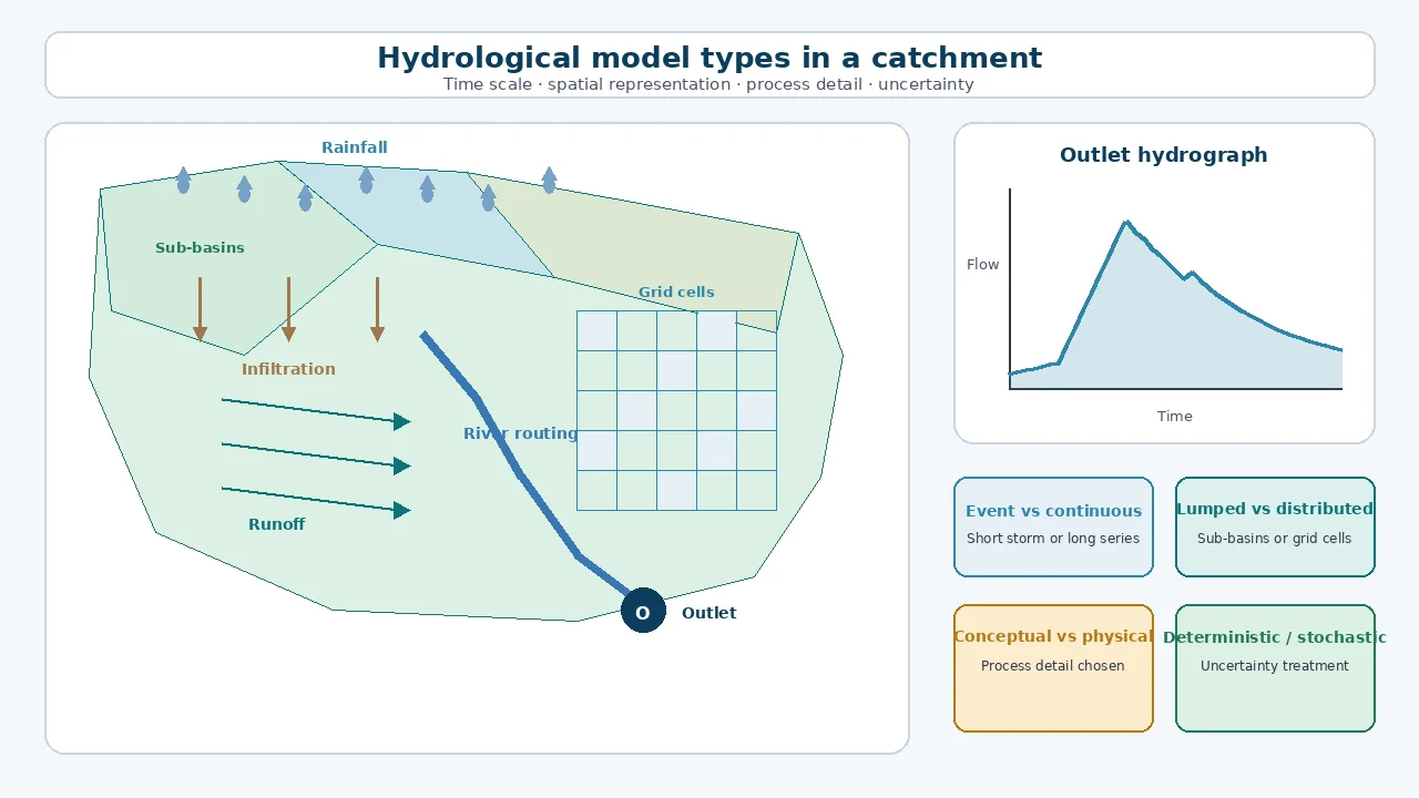
The main types of hydrological models can be classified by time scale, spatial representation, process description and treatment of uncertainty. Common choices include event or continuous models; lumped, semi-distributed or distributed models; empirical, conceptual or physically based models; and deterministic or stochastic models. The right model is the simplest defensible structure that represents the processes, scale and outputs required by the engineering decision.
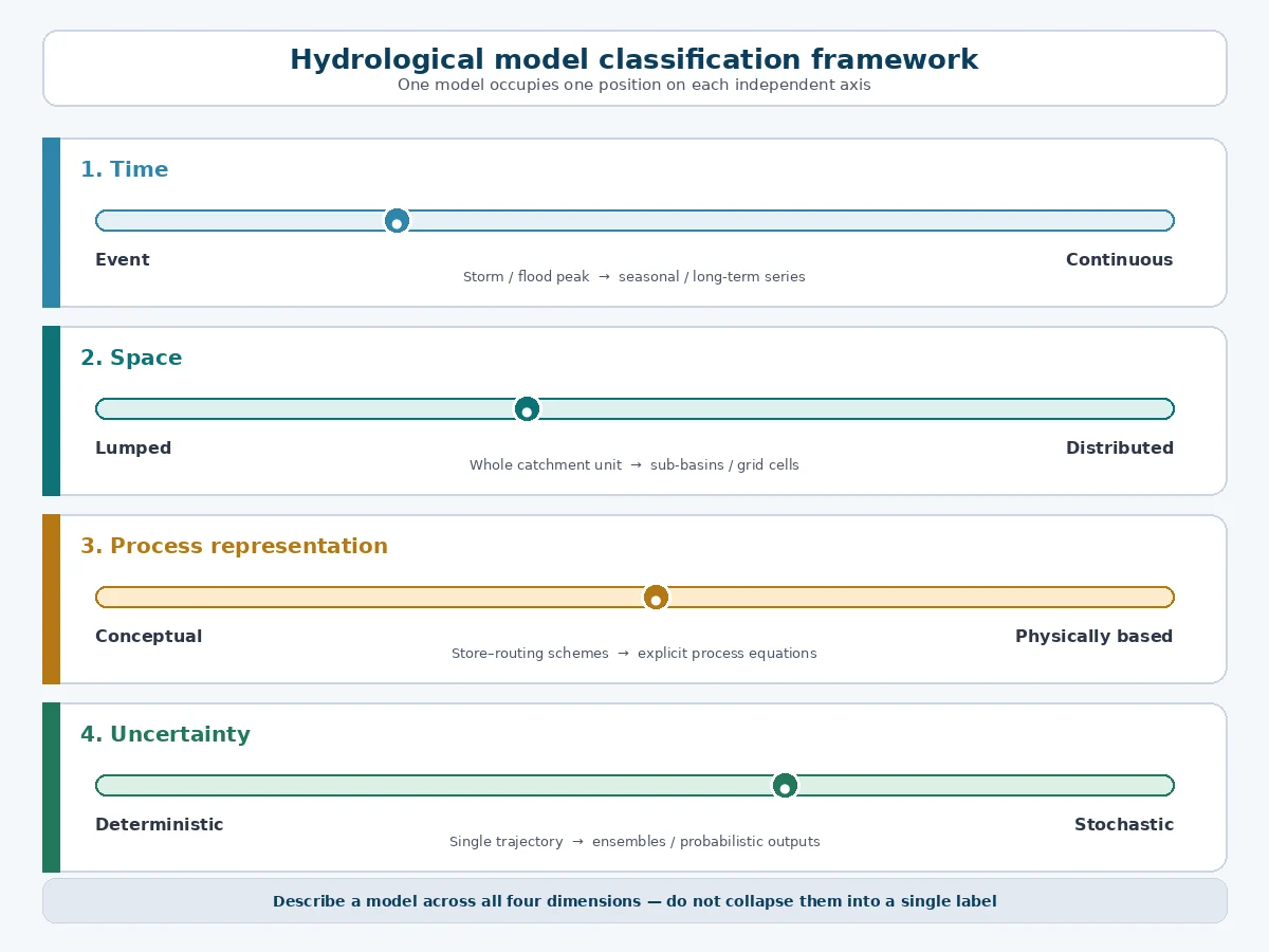
These classifications overlap. A model may be continuous, semi-distributed, conceptual and deterministic at the same time. Engineers should therefore describe a model across several dimensions rather than assign it one vague label. This article provides a consistent classification and a practical way to select amononditions between events.
Spatial detail changes data and computation. Lumped, semi-distributed and distributed structures represent catchment variability at progressively finer levels.
Uncertainty never disappears. Input, structure and parameter uncertainty should be tested and communicated regardless of model type.
A hydrological model is a simplified representan a single method.
Hydrological model classification matrix
Classification dimension
Principal types
Decision it clarifies
Simulation period
Event; continuous
Is the study concerned with one storm or changing catchment state over time?
Spatial representation
Lumped; semi-distributed; distributed
How explicitly must the model represent variation across the catchment?
Process representation
Empirical; conceptual; physically based
How are input–output relationships and water processes described?
Treatment of uncertainty
Deterministic; stochastic or probabilistic
Does one input set produce one output, or are distributions and multiple realisations analysed?
Data and learning approach
Mechanistic; data-driven; hybrid
Is prediction based primarily on process equations, learned relationships or both?
Primary application
Design, forecasting, planning, operations, attribution or scenario analysis
What engineering decision must the outputs support?
mensions of hydrological models” class=”wp-image-2855″ style=”max-width:100%;height:auto” />A hydrological model should be described across several independent classification dimensions.
Event models and continuous models
Event hydrological models
An event model simulates a single storm and the catchment response during and immediately after it. Initial losses, infiltration, runoff transformation and channel routing are configured for that event. Event models are commonly used for design-storm analysis, flood hydrograph estimation and testing temporary or permanent drainage controls where the main question concerns a defined rainfall episode.
USACE guidance identifies the key limitation: event models do not represent drying, evapotranspiration and soil-water redistribution between storms. Unit-hydrograph methods are event models because they respond to excess precipitation generated during a storm (USACE model classification).
Use an event model when the required output is linked to one design or historical storm, initial conditions can be justialance, reservoir inflow, drought, long-term runoff, soil-moisture evolution, seasonal operation or the frequency of system performance under a rainfall record. Continuous simulation can also support flood assessment where antecedent conditions and repeated events materially affect response.
The additional state variables demand more data and checking. A long simulation is not automatically more reliable than a well-defined event model; it simply represents a different question.
Lumped, semi-distributed and distributed models
Lumped models
A lumped model represents a catchment or subcatchment using spatially averaged parameters. Rainfall, losses and response are treated as if their effective values apply across the unit. Lumped models are relatively transparent and economical, making them useful where spatial data are limited, the basin is reasonably homogeneous or the decision concerns flow at one principal outlet.
The limitation is that internal variation may be hidden. Two catchments with the same area-average parameter can respond differently when imperviousness, soils, slope, rainfall or drainage connectivity are distributed differently.
viour rather than simply the availability of map layers.
Distributed models
A distributed model calculates processes across grid cells or small spatial units. USACE defines distributed models as explicitly considering geographical variation, while spatially averaged models ignore or average that variation (USACE model classification).
Use a distributed approach when spatial patterns are central to the decision, such as localised rainfall, land-use change, soil variation, snow processes or the location of interventions. Distributed structure increases data, parameter, computational and validation demands. Fine resolution cannot compensate for uncertain rainfall or poorly observed processes.
Empirical, conceptual and physically based models
Empirical models
Empirical models derive relationships from observations without attempting to represent every physical mechanism. Regression, regional equations and fitted input–output relationships can be efficient for screening, ungauged estimation or aan direct field measurements.
Conceptual models balance interpretability and practicality and are widely used for event and continuous rainfall–runoff modelling. Their flexibility creates a calibration risk: different parameter sets can sometimes reproduce similar outlet flows while representing internal processes differently.
Physically based models
Physically based models use equations intended to represent processes such as infiltration, surface flow, unsaturated flow, energy balance or channel hydraulics. They can support spatial and scenario analysis when process understanding and data are adequate.
The name does not mean assumption-free. Scale, boundary conditions, numerical resolution and parameter estimation still simplify reality. A physically based model with poorly supported inputs may be less defensible than a simpler conceptual model calibrated and tested for the decision.
Data-driven and hybrid models
Data-driven models learn relationships from observed inputs and outputs using statistical or machine-learning methods. They may provide strong prediction within the training domain, particularly where large, representative datasetsg/water-resources-engineering-hydrology”>Water Resources Engineering and Hydrology Course.
Deterministic and stochastic models
A deterministic simulation returns one model output for one set of inputs and parameters. This is convenient for design scenarios and operational runs, but the single hydrograph should not be confused with certainty. Rainfall, initial conditions, parameters and model structure remain uncertain.
Stochastic or probabilistic approaches represent one or more uncertain quantities through distributions, ensembles or repeated realisations. They are useful when the decision depends on the range and likelihood of outcomes, forecast spread or parameter uncertainty.
USACE’s uncertainty guidance distinguishes errors in meteorological inputs, process representation and parameter values, and describes Monte Carlo sampling as one way to estimate uncertainty in simulated watershed response (HEC-HMS uncertainty analyses). Communicate the uncertainty sources that the analysis includes and those it omits.
EPW hydrological model selecticontrols, water quality or antecedent storage
Long-term water balance or yield
Continuous conceptual or process-based model
Snow, groundwater, abstraction, land-use or climate processes needing explicit representation
Operational flood forecasting
Continuous or state-updated model with forecast inputs
Ensemble rainfall, data assimilation and uncertainty ranges required for decisions
Land-use or climate scenario assessment
Continuous model with defensible process sensitivity
Spatial changes, non-stationarity and scenario uncertainty central to the study
Data-rich outlet prediction
Conceptual, data-driven or hybrid alternatives compared transparently
Representative records, operational monitoring and out-of-sample validation available
lution to the decision rather than the available software.
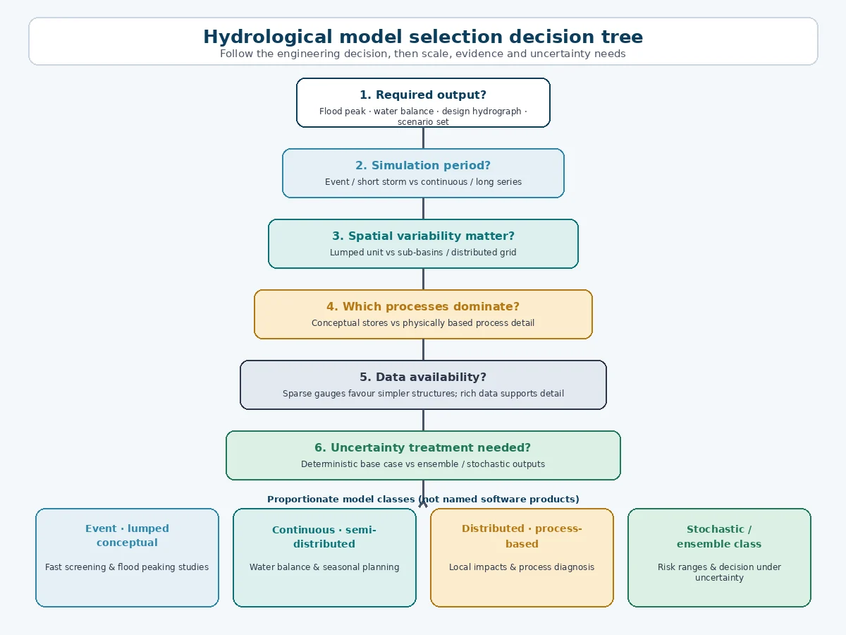
What observations are available? Assess rainfall, flow, level, evapotranspiration, soils, land use, operations and rating uncertainty.
Can parameters be estimated and tested? Separate measured quantities from calibrated effective values.
How will performance be evaluated? Use multiple periods, events, locations and metrics that relate to the decision.
How will uncertainty affect action? Test inputs, parameters, structure and scenarios in proportion to the consequence of error.
Worked example: selecting a model for an urban catchment
A municipality needs to size storage for a mixed urban catchment and assess downstream peak flow. Available information includes rain gauges, short flow records, drainage mapping, land use and a digital terrain model. The main decision concerns a defined design storm, but existing ponds and strong imperviousness differences affect tributary timing.
ng-term pond performance or water balance becomes part of the brief, a continuous component is added because the decision—not software availability—has changed.
Common model-selection mistakes
Selecting software before defining the decision. Start with outputs, processes and evidence.
Equating finer resolution with accuracy. Resolution increases value only when inputs and validation support it.
Calibrating and validating on the same period. Test performance on independent events or periods where feasible.
Judging performance with one metric. Examine volume, peak, timing, low flow or spatial behaviour according to the decision.
Ignoring parameter identifiability. A good outlet fit can conceal compensating parameter errors.
Using an event model for long-term water balance. Inter-event drying and storage state must be represented.
Reporting one deterministic result without uncertainty. Explain plausible input, parameter and structural variation.
Ready to choose and review hydrological models more confidently? Review the water-resources course content and available locations, or request tailored in-house training for your engineering team.
Hydrological models are best classified across several dimensions: event or continuous, lumped or distributed, empirical or process-oriented, and deterministic or stochastic. Each classification reveals an assumption that matters to engineering use.
The most defensible model is not the one with the most parameters or smallest grid. It is the simplest structure that represents the controlling processes at the required scale, can be supported by available evidence, and communicates uncertainty in a form that decision-makers can use.
Sources and References
US Army Corps of Engineers, Hydrologic Engineering Center. Uncertainty Analyses.
A single lumped model would be transparent but could hide the timing and storage differences. A fully distributed process model would require spatial parameters and validation evidence that the project does not possess. The team therefore starts with an event-based, semi-distributed conceptual model, dividing the area into hydrologically meaningful subcatchments and representing storage and routing explicitly.
Historical events are used to test loss, transformation and routing assumptions. Sensitivity analysis covers initial moisture, rainfall distribution and storage parameters. The design output is reported with assumptions and scenario ranges rather than as a precise forecast. If loModel selection should follow the engineering decision, process scale, evidence and required uncertainty treatment.
Seven selection questions
What decision will the model support? Define the user, output, location, time step and acceptance criterion.
Which processes control that output? Identify rainfall, infiltration, storage, snow, groundwater, abstraction, routing or regulation as relevant.
What spatial and temporal scale is necessary? Match resoon framework
Study need
Proportionate starting point
Evidence that may justify greater complexity
Peak flow for a defined design storm
Event, lumped or semi-distributed conceptual model
Strong spatial rainfall, tributary timing, reservoirs or local interventions
Urban drainage and storage design
Event or continuous semi-distributed catchment model linked to hydraulic analysis
Surface–sewer interaction, spatial exist. Hybrid models combine learned components with water-balance or process constraints.
Use these models when predictive skill, data coverage and deployment requirements justify them. Check non-stationarity, missing data, extrapolation, interpretability and physical consistency. A high validation score at one gauge does not prove plausible behaviour under an unseen climate or land-use scenario.
Professionals who want to connect model structure, hydrological processes, calibration and water-management decisions can explore EPW’s Conceptual models
USACE HEC-HMS overview). That breadth illustrates why “hydrological model” describes a family of representations rather thg the options.
Key takeaways
Start with the decision and required output. Design peak flow, water balance, flood forecasting and climate-impact assessment do not require identical models.
Complexity must be earned by evidence. Additional parameters and spatial detail create value only when data, calibration and the decision can support them.
Event and continuous models answer different time questions. One represents a storm and its immediate response; the other tracks c

 USACE HEC-HMS overview